One of the earliest cartographic representations of the Gulf Stream, as much a diagram as a chart, was drawn in 1770 by (or more strictly for) the American statesman, savant and polymath, Benjamin Franklin, when he was in charge of the colonial post office. His initiative followed a complaint by the Board of Customs at Boston to the Lords of the Treasury in London that mail packets from Falmouth to New York regularly took two weeks longer than American merchantmen sailing from London to Providence, Rhode Island. The Americans, it seems, followed a northerly route, whereas the Falmouth masters, apparently unaware that they were stemming the current, sailed straight for their destination.
Franklin’s chart showing the course of the Gulf Stream was drawn up in consultation with Captain Timothy Folger of Nantucket and printed by the General Post Office.
Blondie Hasler, who inaugurated the first east-to-west singlehanded transatlantic race, was similarly impressed with the idea of keeping north, largely on the evidence of a Captain Hare, RN, who made over 100 crossings of the North Atlantic in the days of sail. Captain Hare pointed out, amongst other things, that ships from Scotland invariably arrived in America before ships from the Channel. The Germans too, it may be noted, favoured a northerly route in the days of sail, although this may in part have been to save sailing through the Channel.
More important than the Gulf Stream was the fact that a high northern route should pass north of the stream of depressions that moves eastward across the ocean and so benefit from the easterlies on their northern side.
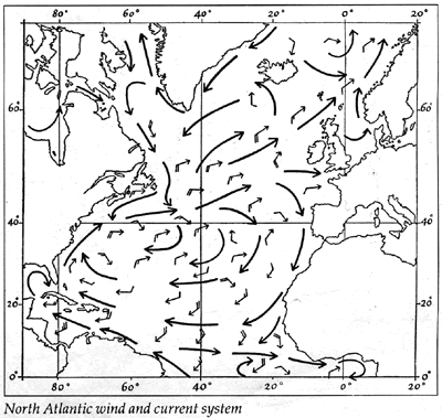
The general situation that makes it more difficult to cross the North Atlantic from east to west in the northern part of the ocean, from which the whole notion of routeing derives, is apparent from any pilot chart. The prevailing wind direction rotates clockwise, so that there are westerlies up north and easterlies down south, although each depression superimposes its own local anti-clockwise system on the general pattern. The currents, by and large wind-driven, are dominated by the Gulf Stream, which flows at full strength out of the Florida Strait and up the eastern seaboard of the States, diminishing in strength all the time, until it turns eastward off the Tail of the Bank and merges with the North Atlantic drift. The cold Labrador current, which finally sets in a general southwesterly direction down the Labrador coast, brings with it, during the spring and early summer, ice from the northern glaciers and, with the ice, fog so that the area between Newfoundland and Nantucket is one of the foggiest in the world.
Pilot charts are based on averages, but the most constant feature of both winds and ocean currents in any part of the world at any time of year is their variability, and the interpretation of the chart to derive a route for any particular occasion is as arcane a business as reading a horoscope.
Maury, on whose researches the standard American pilot charts are based, advocated using his Wind and Current Charts, and the tables that then went with them, to determine, when the wind heads, the direction from which, on average, the new wind might be expected and thus which board to take. This preoccupation with keeping upwind would mean little to the modern yachtsman accustomed to windward ability, and when Phil Weld consulted a meteorologist before the 1980 Observer Singlehanded Transatlantic Race (which he won), what he sought for Moxie was not fair winds but winds from any direction provided they blew not less than three and not more than 35 knots. The advice came as a simple rule of thumb: get south of 45°N before crossing 35°W. In this way, it was estimated, he should keep clear of the depressions that tend to curve north-east at that time of year after they leave Newfoundland.
For the first OSTAR in 1960, there was no restriction as to route or size. The race would be self-handicapping: the larger the boat, the higher its potential speed but on the other hand the harder it would be for a man on his own to maintain that speed. This is still the situation, but whereas it was imagined in those far-off days that the absence of rules would lead to a class of easily handled and modestly sized deep-sea cruising boats, it has, in fact, led to a fleet with the widest possible range of speeds.
It seems doubtful whether today any but the smaller vessels in the fleet, for whom headwinds of Force 7 would mean standing still, will be interested in the standard routes recognised in the days of sail.
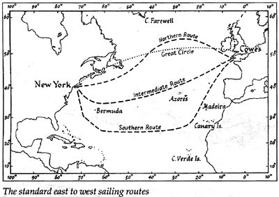
The direct route, which lies just south of the Great Circle (which passes over land), is somewhat gloomily described in the Admiralty’s Ocean Passages for the World as ‘seldom possible’, as with headwinds and contrary currents it may well have been in the days of the windjammer. Clearly, there must be weighty reasons for not taking the shortest sailing route, and since in any case, once the wind heads, it is the normal practice to go on to that tack which looks up best for the destination, there will be many reluctant to add speculatively to the nominal mileage.
Humphrey Barton and Kevin O’Riordan crossed the Atlantic from east to west some 40 years ago in Vertue XXXV along a route corresponding roughly to the low-powered steamer route shown on the pilot charts. This intermediate route north of the Azores generally skirts the southern limits of the Gulf Stream and crosses it at right angles in the vicinity of 65°W. It was not recognised in the days of sail, but recently, in one form or another, seems to have grown in popularity for the more modest sized vessel.
For those with the stomach for fog and cold, the inevitable hazard from ice and the probability of strong winds, a route going up to about 55°N in mid-ocean undoubtedly presents one possibility of a fast passage, and a number have been successfully made. But, comfort apart, the route has its drawbacks, not the least of which is the probability of light headwinds over the last 1,000 miles. Furthermore, although less important, the constancy of the Labrador Current, which might be expected to give a lift down the Nova Scotian coast towards New England, is such that in practice one can expect to find it setting in almost any direction depending on what the wind has been doing. Again, whether passing north of the depressions is invariably advantageous, must be open to question.
In the course of a voyage from Iceland to Newfoundland in a Nicholson 38, for example, Tom Follett found that the boost they got in the early stages of a gale caused by the passage of a depression to the south just about cancelled out as the wind continued to back from north-west as the depression passed. During that time, with the wind continually backing, a confused sea got up so that when the wind finally died down practically no progress could be made, even with the engine. Without an engine, comments Follett, it would have been a very slow passage indeed.
Not much can be inferred from a single passage, but Follett’s views merit particular attention. A master seaman who had given much thought to the problem of sailing routes, he distinguished himself during the 1968 OSTAR, in the proa Cheers, by covering a shorter distance than any other competitor over a circuitous route well south of the rhumb line.
‘There is,’ wrote Captain Beecher, ‘another route which, although longer as to the distance, appears preferable.’ Beecher, an officer in the Admiralty Hydrographic Service during the closing years of the last century, wrote an admirable study on navigating the North Atlantic.
The route he had in mind picks up the Trade Winds somewhere between Madeira and the Azores, crosses the ocean below 25°N and comes north again in about 65°W. ‘If the time occupied in the passage might appear greater in consequence of the distance,’ Beecher argues, ‘it is really less as to the speed with which the vessel would sail from port to port.’ That is, course, the nub of the question, whether increasing the nominal distance from some 3,000 to a massive 5,000 miles can ever be justified by the increase in speed from sailing with fair winds and a favourable current.
I took Jester along the Trade Wind route in 1968. We averaged 93 miles a day (in spite of prolonged calms at one stage) but covered a vast distance and took 57 days over it. ‘My own feeling,’ wrote Blondie Hasler afterwards, ‘is that there cannot be more than one year out of five in which Jester would actually make a faster passage by the southern than by the northern route…’
If the new Jester gets to the start of the next singlehanded transatlantic race, it would nevertheless be tempting to see if this is one of the five.
Copyright © Mike Richey (Yachting Monthly April 1992)
